


OR-6098451--Bresse (La):CIRCUIT VTT N°13

Alfredy
User GUIDE
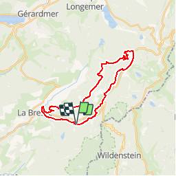

Length
25 km

Max alt
1176 m

Uphill gradient
730 m
Km-Effort
35 km

Min alt
651 m

Downhill gradient
734 m
Boucle
Yes
Creation date :
2018-05-15 13:22:34.77
Updated on :
2018-05-15 13:27:54.304
2h20
Difficulty : Very easy

FREE GPS app for hiking
 SityTrail
IGN / Geographical institutes
SityTrail Plus
The world is yours!
About
Trail Mountain bike of 25 km to be discovered at Grand Est, Vosges, La Bresse. This trail is proposed by Alfredy.
Description
Circuit présenté dans la Carte Hautes-Vosges VTT, disponible à l'Office de Tourisme de La Bresse sur demande.
Départ: Domaine du haut des Bluches
Accès libre permanent. Itinéraire balisé.
Positioning
Country:
France
Region :
Grand Est
Department/Province :
Vosges
Municipality :
La Bresse
Location:
Unknown
Start:(Dec)
Start:(UTM)
344767 ; 5318256 (32T) N.
Comments